Bottom Hardness &
Vegetation Layers
Don’t fish dead water – Make every cast count
with Genesis Edge.
They say 90% of the fish are in 10% of the waterbody. Much of the time, they’re on hard-bottom areas and in submerged vegetation. With Genesis Edge, such areas display on your GPS map, helping you find them faster, target them more efficiently and catch more and bigger fish.
Fish love hard bottoms. They feed on ‘em, breed on ‘em, follow their edges like roads. They love submerged vegetation as well, ambushing baitfish in grass flats, deep weedlines, isolated patches on breaklines and more.
With Genesis Edge, anglers can create their own private map layers that show the location, shape and depth of areas of submerged vegetation and varying bottom hardness. To get started, subscribe to Genesis Edge, then record sonar data from a compatible* fish-finder/GPS unit while “graphing” the water of most interest to you. Upload your data to C-MAP Genesis, then download your custom map to use on the sonar unit(s) on your boat.
Bottom Hardness Layer
Many fisherman “beat the bank” because they have more confidence targeting visible shoreline cover than offshore bottom structure. Those shallow fish get pounded hard, making them harder to catch.
With a Genesis Edge bottom-hardness map, however, you can fish the bottom as confidently as you do the bank, targeting the most-productive places – classic spot-on-the-spot areas – on offshore structure like ledges, sunken islands, saddles and more.
Genesis Edge makes such areas stick out like “Fish Here!” signs on your map. It overlays onto your contour lines a color-coded representation of the size, shape and location of areas of different bottom hardness: dark orange areas show the hardest bottom; a lighter orange indicates the next-hardest bottom; tan is the next-hardest bottom; and pale yellow shows the softest-bottom areas.
To catch more and bigger fish, avoid dead water and target transition edges on break-lines between harder and softer bottoms and the harder sections of points, humps, inside turns and more.

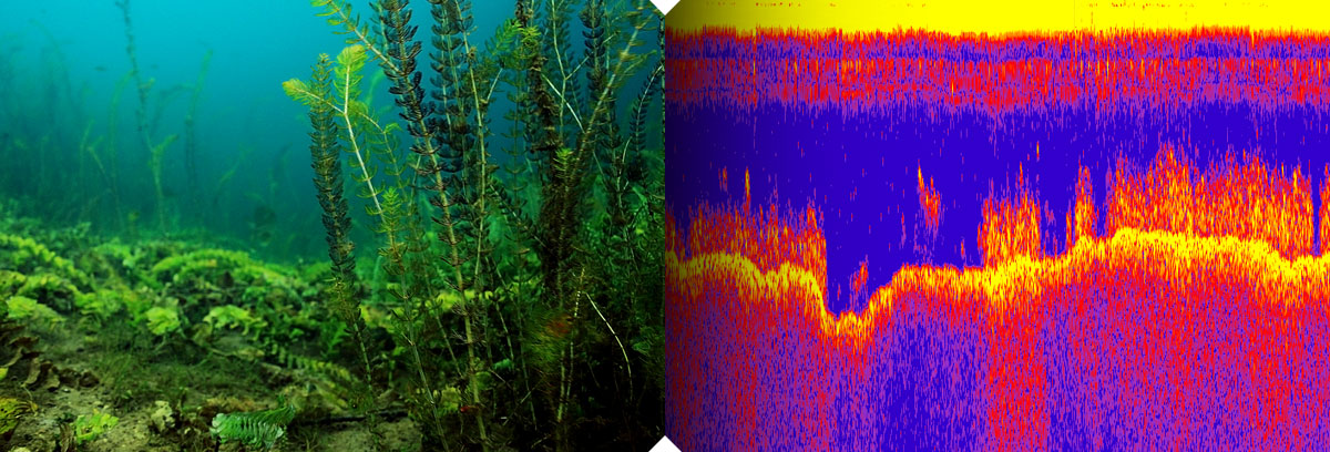
Submerged Vegetation Layer
It’s no secret that big fish ambush baitfish in submerged vegetation. What’s not always known however, is where the good green stuff is, and what areas within it likely hold the most fish. In most weather and water conditions, submerged vegetation is not visible to the naked eye, so you have to go searching for it. And even when you see a patch on your sonar screen, you won’t know its full size, shape or thickness.
Genesis Edge’s vegetation layer, however, shows fish-holding holes in vast grass flats, depicts fish-populated points and inside-turns on deep weedlines, and more. Atop your blue-scaled contour map, it places bright-green overlays the size and shape of areas of submerged vegetation, making it as easy to see the best places to cast as when you’re throwing to visible cover like docks and laydowns.
* Most modern Lowrance, Simrad and B&G sonar/GPS units can display C-MAP Genesis and Social Map charts as well as record sonar log files.